


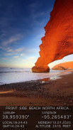
GPS Camera with latitude and longitude

وصف لـGPS Camera with latitude and longitude
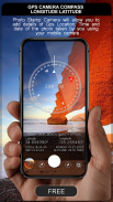
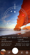
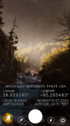
GPS Camera can help you to add the address, location coordinates direction, altitude, current date & time & note in the picture.There is a coordinate converter to switch between any of the common coordinate systems including Lat/Long, UTM, and MGRS so it can work with any physical map.
You can also set the camera function , such as flash on / off, night, zoom, the resolution of the camera ...
After you finish your shot, you can save it or share it with your friends directly in the action press the icon. You can also view photos you took using his picture browser.
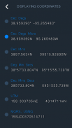
* Coordinate types:
- Dec Degs (DD.dddddd˚)
- Dec Degs Micro (DD.dddddd "N, S, E, W")
- Dec Mins (DDMM.mmmm)
- Deg Min Secs (DD°MM'SS.sss")
- Dec Mins Secs (DDMMSS.sss")
- UTM (Universal Transverse Mercator)
- MGRS (Military Grid Reference System)
يمكن أن تساعدك كاميرا GPS على إضافة العنوان وموقع إحداثيات الموقع والارتفاع والتاريخ والوقت الحالي والملاحظة في الصورة. يوجد محول إحداثي للتبديل بين أي من أنظمة الإحداثيات الشائعة ، بما في ذلك Lat / Long و UTM و MGRS ، يمكن أن تعمل مع أي خريطة المادية.
يمكنك أيضًا ضبط وظيفة الكاميرا ، مثل تشغيل / إيقاف الفلاش والليل والتكبير / التصغير ودقة الكاميرا ...
بعد الانتهاء من اللقطة ، يمكنك حفظها أو مشاركتها مع أصدقائك مباشرة في الإجراء ، اضغط على الرمز. يمكنك أيضًا عرض الصور التي التقطتها باستخدام متصفح الصور الخاص به.
* تنسيق الأنواع:
- ديسمبر Degs (DD.dddddd˚)
- Dec Degs Micro (DD.dddddd "N، S، E، W")
- ديسمبر دقيقة (DDMM.mmmm)
- Deg Min Secs (DD ° MM'SS.sss ")
- ديسمبر دقيقة (ثوانٍ (DDMMSS.sss ")
- UTM (مركاتور مستعرض عالمي)
- MGRS (النظام المرجعي للشبكة العسكرية)


